


SityTrail hiking trail GPS
Описание на SityTrail hiking trail GPS
Отидете и открийте всички пътеки по света
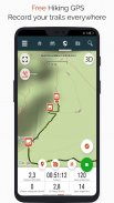
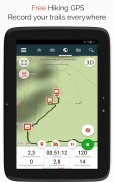
• Запишете пътеките си, докато правите HD и географски маркирани снимки на вашите приключения.
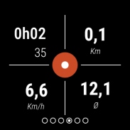
• Изминато разстояние, км-усилие, средна скорост, изгорени калории и др.
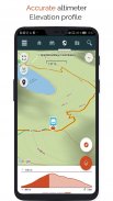
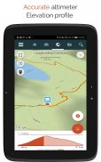
• Точен алтиметър, изчисляване на разликите във височината и профил на надморската височина, показващ вашето текущо местоположение.
• Аларма, когато излезете от пътя на следваната следа. Вече няма нужда да се връщате назад!
• Автоматично задействане на интересни точки с текст-към-говор.
• Създайте безплатен акаунт и всички ваши данни ще бъдат достъпни навсякъде на всяко устройство.
• Лесно създаване на пътеки и интересни точки от нашия уебсайт.
• С нашия онлайн редактор създайте свои собствени пътеки с помощта на уеб браузър на вашия PC/Mac и след това достъпете ги директно от вашия смартфон, за да ги изпитате на земята.
• Сортирайте и класифицирайте вашите пътеки и точки на интерес във вашите собствени списъци.
Стигнете по-далеч и станете PREMIUM потребител!
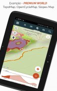
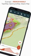
• Изтеглете световни топографски карти за офлайн употреба.
• Открийте туристически пътеки на GR, европейски туристически маршрути, маршрути на Сантяго де Компостела за поклонници и др.
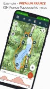
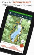
• Добавете топографски карти по ваш избор от IGN Франция, IGN / NGI Белгия, IGN Испания, swisstopo, Австрия, САЩ (USGS топографско картографиране), Канада (Toporama).
• Можете също така да откриете всички велосипедни мрежи: Greenway мрежа във Франция, Ravel в Белгия, европейски велосипедни маршрути, възлови мрежи във Фландрия и Холандия.
• А през зимата открийте всички ски писти с техните имена.
• Достъп до публичния каталог на пътеки от членове и общности на SityTrail.
• Разширени функции за проследяване и насочване с изчисляване на оставащото разстояние и време и гласови инструкции на кръстовища.
• Отидете по-далеч и трансформирайте любимите си пътеки в истински мултимедийни ръководства с текст, снимки, видео връзки и ги споделете с общността на SityTrail.
• Създайте свои собствени туристически общности и управлявайте своите членове и емисии с новини.
• Създавайте пътеки с нашите разширени функции за редактиране на пътеки чрез нашия уебсайт.
• Печат на пътеки в PDF формат с QR кодове. (A4, A3).
• Достъп до статии в Wikipedia с географски етикети от нашия модул SityTrip.
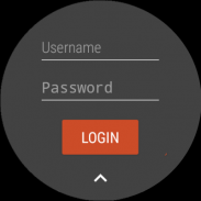
Запишете следа на часовника си с Wear OS
Можете да записвате пътека на часовника си с Wear OS в самостоятелен режим (не е свързан към смартфон с Android) или в режим на сдвояване (свързан към смартфон с Android).
Приложението също така позволява влизане във вашия съществуващ акаунт в SityTrail (от екрана, който е най-вляво), когато часовникът се използва в самостоятелен режим.
Важна информация
• Някои функции се нуждаят от интернет връзка.
• Продължителната употреба на GPS може да намали нивата на батерията.
SityTrail hiking trail GPS - Version 12.15.1.38
(13-12-2024)SityTrail hiking trail GPS - APK информация
APK версия: 12.15.1.38Пакет: com.geolivesLatest Version of SityTrail hiking trail GPS
Други версии


 4.34
4.34


Apps in the same category

You may also like...


